
Discovering Arts Integration More Info
EcoJustice in my Community
From Forestbrook to Forest Gone: Deforestation
and Overdevelopment in South Carolina
For this week’s EcoJustice Project, I didn’t have to travel far. An important area in my community used to be a forest, and in less than two years this ecosystem and the lungs of our rural community have been lost. The forest that once gave the place its name is gone. The rural community has become less alive and less healthy due to constant deforestation and overdevelopment. Over the past two years, this area has been under continuous development, resulting in the removal of large section of forest that once surrounded the community. What was once rural is now becoming a suburban development. The space is now dominated by exposed mixed soil, heavy layers of clay, machinery that comes and goes, piles of construction debris, and the absence of the tree canopy that previously defined the area.
While trying to stay balanced in the middle of an active construction zone, I found it difficult to attune myself to space. The air quality felt noticeably worse charged with dust, debris, and construction materials drifted constantly through the air, raising real concerns about respiratory health. This is an ongoing worry for local residents, especially children and older adults.
Cars and heavy machinery moved in and out without awareness of the sadness in the landscape, a landscape that is being permanently altered, lost, gone. I saw signs marking the upcoming road expansion and watched machines installing silt fencing along property lines to prevent erosion and keep soil from washing into the newly constructed waterways. Soon, this area will become a widened four‑lane road, and I can’t help reflecting on how much more pollution this will bring.
Prolonged exposure to this level of construction, noise, and air contamination feels harmful. The constant disruption created a sense of stress and disconnection rather than safety or calm. I brought my art materials with me, hoping to sketch or paint on site, but the sadness of the place overwhelmed me. I didn’t feel like creating anything.
Ecologically, the impact of deforestation in this area is unmistakable. Many native trees have been cut down, leaving the soil exposed, eroded, and unstable. Birds that once filled the neighborhood with movement and sound are now rarely seen, and forest animals that depended on this habitat for food and shelter have been visibly displaced. The loss of biodiversity has turned what was once a thriving ecosystem into a fragmented and degraded landscape.
I don’t feel like painting or sketching on site, I still feel compelled to preserve something from the place beyond photographs. I begin by picking up a few fallen leaves and arranging them side by side. I take a page from my sketchbook and place it on the ground. Instead of creating a traditional botanical drawing. I decided that the most appropriate way to honor space is through botanical printing. I brought eco‑friendly, biodegradable watercolor pigments with me, which allows me to create eco‑prints directly from the leaves. After finishing the prints, I take photographs and document the process on site, gathering a visual record that feels both creatively aligned with the mood and ecological respectful.
Reflecting on this experience, I’m deeply concerned about the long‑term consequences of overdevelopment on our immediate environment and local ecosystem. The removal of forests not only affects wildlife but also diminishes the health, resilience, and sense of connection for the human community. This space now reflects an imbalance where economic development has taken precedence over ecological sustainability and community well‑being, raising important environmental justice concerns for this area.
Artifacts Documented from Week 2 EcoJustice Field Study
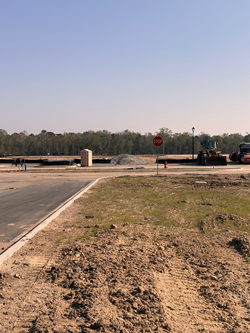
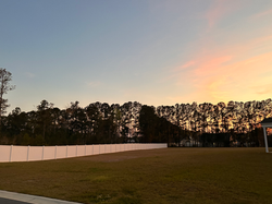
1- Photographic Documentation of the Construction Zone
Photographs showing bulldozers, trucks, road expansion equipment, exposed mixed soil, and the visible forest line, illustrating the scale of human intervention in the former woodland.
2- Chemically Burned or Prescribed Ecological Thinning Areas
Images and notes documenting patches of vegetation affected by chemical treatment or controlled clearing, showing human‑driven ecological alteration.
3- Silt Fencing Installation Along Property Lines
Photos of erosion‑control barriers placed around the construction site, highlighting attempts to manage soil disturbance and prevent runoff into newly installed waterways.
4- Human‑Generated Trash from Construction Workers
Documentation of discarded materials like plastic bottles, food wrappers, and construction debris revealing ongoing contamination and negative human impact on the environment.
5- Deforestation Evidence: Cut Tree Trunks and Removed Canopy
Visual records of tree stumps, exposed roots, and cleared land where the forest once stood, showing direct evidence of habitat loss and road expansion.
6- Eco‑Printed Botanical Artwork
Watercolor eco‑prints created from fallen leaves collected on site, using biodegradable pigments and watercolor paper as an ecological and artistic response to the altered landscape.
7- Collected Natural Materials
A small selection of fallen leaves, broken branches, and dead sprouts gathered from the site as physical evidence of ecological disturbance.

EcoJustice
in my Community
Week 2
 |  Photographic Documentation of the Construction Zone Photographs showing bulldozers, trucks, road expansion equipment, exposed mixed soil, and the visible forest line, illustrating the scale of human intervention in the former woodland. Location: Forestbrook, South Carolina Time: March 22, 2026. 4:39 PM |  Photographic Documentation of the Construction Zone Photographs showing bulldozers, trucks, road expansion equipment, exposed mixed soil, and the visible forest line, illustrating the scale of human intervention in the former woodland. Location: Forestbrook, South Carolina Time: March 22, 2026. 4:39 PM |  Photographic Documentation of the Construction Zone Photographs showing bulldozers, trucks, road expansion equipment, exposed mixed soil, and the visible forest line, illustrating the scale of human intervention in the former woodland. Location: Forestbrook, South Carolina Time: March 22, 2026. 4:39 PM | 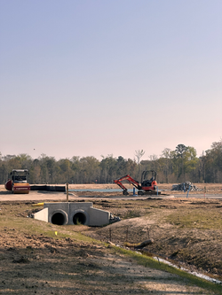 Photographic Documentation of the Construction Zone Photographs showing bulldozers, trucks, road expansion equipment, exposed mixed soil, and the visible forest line, illustrating the scale of human intervention in the former woodland. Location: Forestbrook, South Carolina Time: March 22, 2026. 4:39 PM |  Photographic Documentation of the Construction Zone Photographs showing bulldozers, trucks, road expansion equipment, exposed mixed soil, and the visible forest line, illustrating the scale of human intervention in the former woodland. Location: Forestbrook, South Carolina Time: March 22, 2026. 4:39 PM |
|---|---|---|---|---|---|
 |  Photographic Documentation of the Construction Zone Photographs showing bulldozers, trucks, road expansion equipment, exposed mixed soil, and the visible forest line, illustrating the scale of human intervention in the former woodland. Location: Forestbrook, South Carolina Time: March 22, 2026. 4:39 PM | 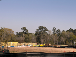 Photographic Documentation of the Construction Zone Photographs showing bulldozers, trucks, road expansion equipment, exposed mixed soil, and the visible forest line, illustrating the scale of human intervention in the former woodland. Location: Forestbrook, South Carolina Time: March 22, 2026. 4:39 PM |  |  |  |
 |  |  |  Photographic Documentation of the Construction Zone Photographs showing bulldozers, trucks, road expansion equipment, exposed mixed soil, and the visible forest line, illustrating the scale of human intervention in the former woodland. Location: Forestbrook, South Carolina Time: March 22, 2026. 4:39 PM |  |  Photographic Documentation of the Construction Zone Photographs showing bulldozers, trucks, road expansion equipment, exposed mixed soil, and the visible forest line, illustrating the scale of human intervention in the former woodland. Location: Forestbrook, South Carolina Time: March 22, 2026. 4:39 PM |
 |  |  Photographic Documentation of the Construction Zone Photographs showing bulldozers, trucks, road expansion equipment, exposed mixed soil, and the visible forest line, illustrating the scale of human intervention in the former woodland. Location: Forestbrook, South Carolina Time: March 22, 2026. 4:39 PM |  |  |  |
 |  |  Silt Fencing Installation Along Property Lines Photos of erosion control barriers placed around the construction site, highlighting attempts to manage soil disturbance and prevent runoff into newly installed waterways. Location: Forestbrook, South Carolina Time: 10 am March 22, 2026 |  Silt Fencing Installation Along Property Lines Photos of erosion control barriers placed around the construction site, highlighting attempts to manage soil disturbance and prevent runoff into newly installed waterways. Location: Forestbrook, South Carolina Time: 10 am March 22, 2026 |  Silt Fencing Installation Along Property Lines Photos of erosion control barriers placed around the construction site, highlighting attempts to manage soil disturbance and prevent runoff into newly installed waterways. Location: Forestbrook, South Carolina Time: 10 am March 22, 2026 |  Silt Fencing Installation Along Property Lines Photos of erosion control barriers placed around the construction site, highlighting attempts to manage soil disturbance and prevent runoff into newly installed waterways. Location: Forestbrook, South Carolina Time: 10 am March 22, 2026 |
 Silt Fencing Installation Along Property Lines Photos of erosion control barriers placed around the construction site, highlighting attempts to manage soil disturbance and prevent runoff into newly installed waterways. Location: Forestbrook, South Carolina Time: 4:40 PM March 22, 2026 |  Silt Fencing Installation Along Property Lines Photos of erosion control barriers placed around the construction site, highlighting attempts to manage soil disturbance and prevent runoff into newly installed waterways. Location: Forestbrook, South Carolina Time: 10 am March 22, 2026 |  |  |  |  |
 |  |  |  |  |  |
 Deforestation Evidence: Cut Tree Trunks and Removed Canopy Visual records of tree stumps, exposed roots, and cleared land where the forest once stood, showing direct evidence of habitat loss and road expansion. Location: Forestbrook, South Carolina Time: 7:41 PM March 22, 2026 |  |  Chemically Burned or Prescribed Ecological Thinning Areas Images and notes documenting patches of vegetation affected by chemical treatment or controlled clearing, showing human‑driven ecological alteration. Location: Forestbrook, South Carolina Time: 7:49 PM March 22, 2026 |  Chemically Burned or Prescribed Ecological Thinning Areas Images and notes documenting patches of vegetation affected by chemical treatment or controlled clearing, showing human‑driven ecological alteration. Location: Forestbrook, South Carolina Time: 7:49 PM March 22, 2026 |  Chemically Burned or Prescribed Ecological Thinning Areas Images and notes documenting patches of vegetation affected by chemical treatment or controlled clearing, showing human‑driven ecological alteration. Location: Forestbrook, South Carolina Time: 7:49 PM March 22, 2026 |  Chemically Burned or Prescribed Ecological Thinning Areas Images and notes documenting patches of vegetation affected by chemical treatment or controlled clearing, showing human‑driven ecological alteration. Location: Forestbrook, South Carolina Time: 7:49 PM March 22, 2026 |
 Chemically Burned or Prescribed Ecological Thinning Areas Images and notes documenting patches of vegetation affected by chemical treatment or controlled clearing, showing human‑driven ecological alteration. Location: Forestbrook, South Carolina Time: 7:49 PM March 22, 2026 |  Chemically Burned or Prescribed Ecological Thinning Areas Images and notes documenting patches of vegetation affected by chemical treatment or controlled clearing, showing human‑driven ecological alteration. Location: Forestbrook, South Carolina Time: 7:49 PM March 22, 2026 |  |  |  Human Generated Trash from Construction Workers Documentation of discarded materials like plastic bottles, food wrappers, and construction debris revealing ongoing contamination and negative human impact on the environment. Location: Forestbrook, South Carolina Time: 10:44 AM March 22, 2026 |  Human Generated Trash from Construction Workers Documentation of discarded materials like plastic bottles, food wrappers, and construction debris revealing ongoing contamination and negative human impact on the environment. Location: Forestbrook, South Carolina Time: 10:44 AM March 22, 2026 |
 Human Generated Trash from Construction Workers Documentation of discarded materials like plastic bottles, food wrappers, and construction debris revealing ongoing contamination and negative human impact on the environment. Location: Forestbrook, South Carolina Time: 10:44 AM March 22, 2026 | 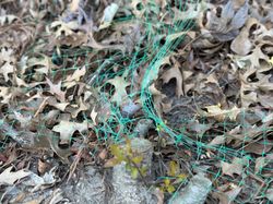 |  |  |  |  Photographically Recorded Collected Natural Materials A small selection of fallen leaves, broken branches, and dead sprouts gathered from across the site as physical evidence of ecological disturbance. Only pictures were taken and all natural material was left on site. Location: Forestbrook, South Carolina Time: 10 am March 22, 2026 |
 Photographically Recorded Collected Natural Materials A small selection of fallen leaves, broken branches, and dead sprouts gathered from across the site as physical evidence of ecological disturbance. Only pictures were taken and all natural material was left on site. Location: Forestbrook, South Carolina Time: 10 am March 22, 2026 |  | 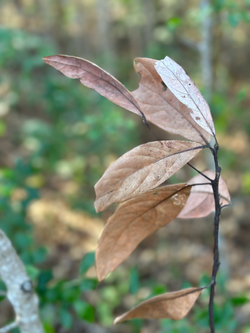 Photographically Recorded Collected Natural Materials A small selection of fallen leaves, broken branches, and dead sprouts gathered from across the site as physical evidence of ecological disturbance. Only pictures were taken and all natural material was left on site. Location: Forestbrook, South Carolina Time: 10 am March 22, 2026 |  Photographically Recorded Collected Natural Materials A small selection of fallen leaves, broken branches, and dead sprouts gathered from across the site as physical evidence of ecological disturbance. Only pictures were taken and all natural material was left on site. Location: Forestbrook, South Carolina Time: 10 am March 22, 2026 |  Photographically Recorded Collected Natural Materials A small selection of fallen leaves, broken branches, and dead sprouts gathered from across the site as physical evidence of ecological disturbance. Only pictures were taken and all natural material was left on site. Location: Forestbrook, South Carolina Time: 10 am March 22, 2026 |  Photographically Recorded Collected Natural Materials A small selection of fallen leaves, broken branches, and dead sprouts gathered from across the site as physical evidence of ecological disturbance. Only pictures were taken and all natural material was left on site. Location: Forestbrook, South Carolina Time: 10 am March 22, 2026 |
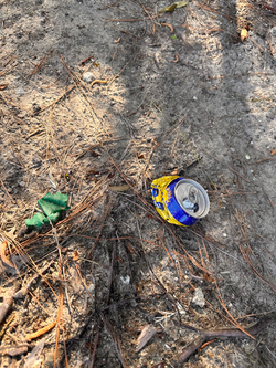 Human Generated Trash Documentation of discarded materials like plastic bottles, food wrappers, and construction debris revealing ongoing contamination and negative human impact on the environment. |  Photographically Recorded Collected Natural Materials A small selection of fallen leaves, broken branches, and dead sprouts gathered from across the site as physical evidence of ecological disturbance. Only pictures were taken and all natural material was left on site. Location: Forestbrook, South Carolina Time: 10 am March 22, 2026 |  Unproper Silt Fencing Installation Neglected Along Property Lines Photos of erosion control barriers placed around the construction site, highlighting attempts to manage soil disturbance and prevent runoff into newly installed waterways. Location: Forestbrook, South Carolina Time: 10 am March 22, 2026 |  |  | 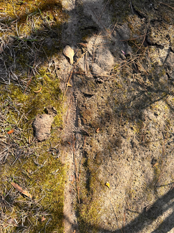 |
 |  Photographically Recorded Collected Natural Materials A small selection of fallen leaves, broken branches, and dead sprouts gathered from across the site as physical evidence of ecological disturbance. Only pictures were taken and all natural material was left on site. Location: Forestbrook, South Carolina Time: 10 am March 22, 2026 |  Eco Printed Botanical Artwork Watercolor eco prints created from fallen leaves collected on site, using biodegradable pigments and watercolor paper as an ecological and artistic response to the altered landscape. Location: Forestbrook, South Carolina Time: 10:40 AM March 22, 2026 |  Eco Printed Botanical Artwork Watercolor eco prints created from fallen leaves collected on site, using biodegradable pigments and watercolor paper as an ecological and artistic response to the altered landscape. Location: Forestbrook, South Carolina Time: 10:51 AM March 22, 2026 |  Eco Printed Botanical Artwork Watercolor eco prints created from fallen leaves collected on site, using biodegradable pigments and watercolor paper as an ecological and artistic response to the altered landscape. Location: Forestbrook, South Carolina Time: 10:51 AM March 22, 2026 | 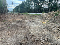 Deforestation Evidence: Cut Tree Trunks and Removed Canopy Visual records of tree stumps, exposed roots, and cleared land where the forest once stood, showing direct evidence of habitat loss and road expansion. Location: Forestbrook, South Carolina Time: 7PM March 22, 2026 |
 Deforestation Evidence: Cut Tree Trunks and Removed Canopy Visual records of tree stumps, exposed roots, and cleared land where the forest once stood, showing direct evidence of habitat loss and road expansion. Location: Forestbrook, South Carolina Time: 7 PM March 22, 2026 | 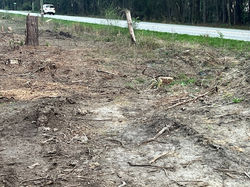 Deforestation Evidence: Cut Tree Trunks and Removed Canopy Visual records of tree stumps, exposed roots, and cleared land where the forest once stood, showing direct evidence of habitat loss and road expansion. Location: Forestbrook, South Carolina Time: 7 PM March 22, 2026 |  Deforestation Evidence: Cut Tree Trunks and Removed Canopy Visual records of tree stumps, exposed roots, and cleared land where the forest once stood, showing direct evidence of habitat loss and road expansion. Location: Forestbrook, South Carolina Time: 7 PM March 22, 2026 |  Deforestation Evidence: Cut Tree Trunks and Removed Canopy Visual records of tree stumps, exposed roots, and cleared land where the forest once stood, showing direct evidence of habitat loss and road expansion. Location: Forestbrook, South Carolina Time: 7 PM March 22, 2026 |  Deforestation Evidence: Cut Tree Trunks and Removed Canopy Visual records of tree stumps, exposed roots, and cleared land where the forest once stood, showing direct evidence of habitat loss and road expansion. Location: Forestbrook, South Carolina Time: 7 PM March 22, 2026 |  Deforestation Evidence: Cut Tree Trunks and Removed Canopy Visual records of tree stumps, exposed roots, and cleared land where the forest once stood, showing direct evidence of habitat loss and road expansion. Location: Forestbrook, South Carolina Time: 7 PM March 22, 2026 |